Rhuddlan Station - erased from the map.
Posted
#141625
(In Topic #7657)
Full Member
A search for the lost station.
At Rhuddlan (between Rhyl and Denbigh) there used to be a station serving local munitions factories during WW1 and providing a link to Ruthin for onward journeys.This is a pic. of a print of a photo of how it once was:

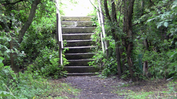
I managed to locate where the station used to be and poked around for evidence.
The station steps are still there, albeit with new handrails.
The bulk of the area is under this pond!
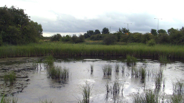
The rest is covered in brambles as it's now a wildlife sanctuary.
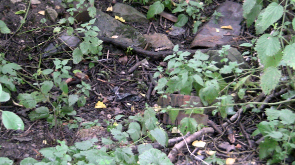
A few lichen covered stones and some unidentifiable debris was all I could find.

I carried on to Rhyl to see if I could find where the tracks branched originally.
This is the road bridge across the tracks:
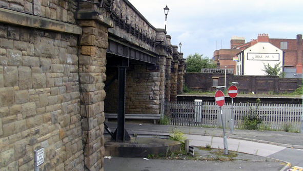
This was my prime candidate for the branch line (note the two stop ends on the right).

Lots more research to do - I haven't done an Internet search yet but an interesting little project.
In passing, here is today's Rhyl Signal Box No1:


Posted
Full Member
Posted

Full Member
'Petermac
Posted

Full Member
Did the branch run on the Kinmel side of the Clwyd ?
I remember a siding feeding back towards the seaward side of the Fforyd Harbour, round the back of the yacht club to a wood yard & quay, probably in late 1960s.
Stubby47's Bespoke Model Buildings
All photos I post are ©Stu Hilton, but are free for use by anyone.
Posted
Full Member
That's where it was.
Posted
Full Member
Edit : Just found this : Disused Stations: Rhuddlan Station
which gives a great history to the line
 Last edit: by Stubby47
Stubby47's Bespoke Model Buildings
All photos I post are ©Stu Hilton, but are free for use by anyone.
Posted
Full Member
The 'environs' may well have extended under the 'new road' however.
(In passing, I had a very close shave a couple of years ago, coming over the flyover there.
The brakes went kaput downhill at 65mph and there was a car in front stopped at the roundabout!
More by luck than judgement I mounted a 7" kerb and managed to stop on some grass.
Phew!)
Posted
Full Member
No time today to go further down (up?) the line to investigate.
Good reference of the footbridge and the seagull defences on the lamps.


Posted
Full Member
Many pictures of this area of interest.
http://www.6g.nwrail.org.uk/welshmetals.html
Posted
Full Member
Platform 1 is long enough to take a loco & 15 coaches. I took some photos of a small weighbridge office near the foot of the 'H' bridge, in about 1980 - shame I have no idea where they got to.
Great to reminisce about this station - thanks DD.
Stubby47's Bespoke Model Buildings
All photos I post are ©Stu Hilton, but are free for use by anyone.
Posted
Full Member
'Petermac
Posted
Full Member
As a schoolboy we were told the history of North Wales, and how the three main holiday resorts were Rhyl, Colwyn Bay and Llandudno. Most of the holiday passengers came from either the Manchester area or the Midlands, and how much you could afford to pay was reflected in the quality of the resort - the cheaper tickets were obviously to Rhyl.
I remember regularly seeing 12 coaches behind a Class 37, from the footbridge nearest my house (and which I had to use to get to and from High School) - the line was straight for quite a few miles eastwards towards Prestatyn so you could see them emerge from the heat haze (remember those) as it got nearer.
Edit: a quick pair of measurements on Google Earth give 994ft for the platform - 16.5 x 60ft coaches, and 2.6miles in a straight lione from the footbridge to the first curve in the track.
Last edit: by Stubby47
Stubby47's Bespoke Model Buildings
All photos I post are ©Stu Hilton, but are free for use by anyone.
Posted
Full Member
I was surprised by the size of Mold Junction in an old photo'.
1 guest and 0 members have just viewed this.